The Brass Monkey Run
The Brass Monkey Run is a recognised biker event, with all proceeds going to charity. Bikers from all over join us on our journey. We encourage all bikers, scooterists, and those who drive classic, vintage, and veteran vehicles to meet and do this run from the pub any time of the year.
Coalville’s History
As the name indicates, Coalville is a former coal mining town. The name originates from the name of the house of the owner of Whitwick Colliery, Coalville House. Coal has been mined in the area since medieval times.
A fire underground at Whitwick Colliery (now under the Morrisons™ supermarket and The Victoria, which was at the time the main pub miners would frequent) led to the deaths of 35 men in 1898. The town grew up with the advent of coal mining, which was pioneered by William Stenson, and involved the sinking of shafts on the Snibston site by George Stephenson.
Stenson is sometimes described as the father of Coalville. The now disused colliery at Snibston has been regenerated into Snibston Discovery Park, a museum focused on transport, mining, and engineering and is well worth a visit.
Donington le Heath Manor House Museum, a family home for more than 700 years, has been redeveloped into a museum in Coalville. The house has close connections to the gunpowder plot of 1605.
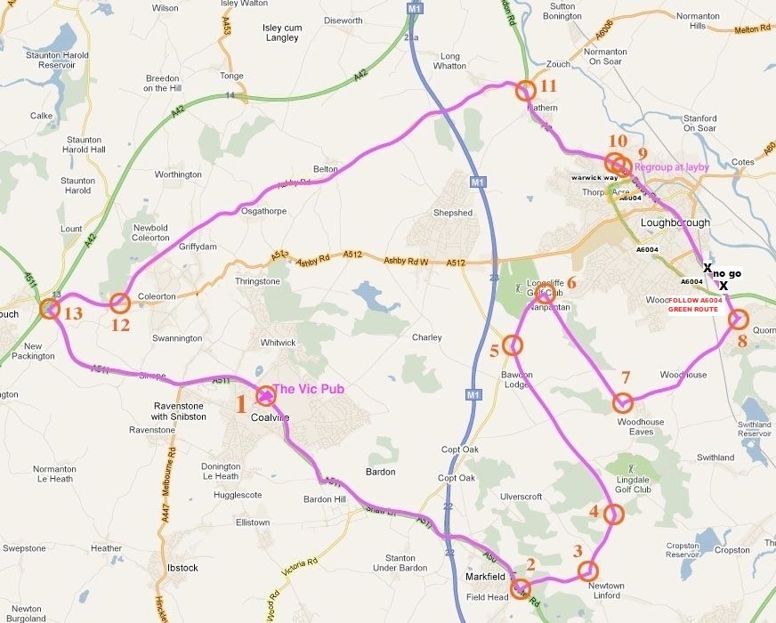
Click on Map to expand
Directions
- The Run Starts from the Vic
- Turn Right out of the Car Park Down the Hill to A511 Island, Turn 1, and Carry on the A511 Island, Turn Right and carry on the A511 towards Leicester to the M1 (4.4.M)
- When Entering the J22 M1 Roundabout, Take the 2nd Exit
- The A511 Becomes the A50 - Follow This to the Next Island (1.3m) and Take the First Exit to Newtown Linford (1.3m) Turn 2
- In Newtown Linford, Turn Left at the T-Junction Turn 3
Side Note: Newtown Linford is a tourist attraction, and if you were to turn right at the T-junction (Turn 3) for (0.5m), then left into Bradgate Park, you can park your bike and take a short stroll to the stream or further and see Old John Tower in Bradgate Park, which is one of the most popular tourist spots in Leicestershire.
Tea and coffee can be found close to the entrance on the opposite side of the road. Discover the picturesque ruins of Bradgate House, the birthplace of Lady Jane Grey who was Queen of England in 1554 for just 9 days at 15 years old. Very interesting and moving articles can be found at The History Learning Site.
(Directions Continued)
- Follow Along and up the Hill for (1.0m) and Turn Left at the Top into Benscliffe Road Turn 4
- If You Look Right as Approaching this Junction, There is Another Entrance to Bradgate Park, dead opposite Turn 4 Which is Closer to the Monument of Old John and Cropston Reservoir
- Continue to a T-Junction (3.1m) Turn 5 and Turn Right towards Loughborough (The Highest Point in the Area and Great Views of Loughborough Can Be Had on the Brow of the Hill)
- Drop Down to the Traffic Lights in Nanpantan (0.9m) and Turn Right Turn 6 onto Woodhouse Lane, Passing Nanpantan Reservoir on Your Left, Following it through to the T-Junction the Other End (2.1m) Turn 7
- Turn Left into the Outskirts of Woodhouse Eaves on Your Right, Home to Award-Winning Chef Paul Leary and Ex-England Goalkeeper, Peter Shilton, Once Lived Here Carry on Down for (2.4m) and You Will Pass through the Village of Woodhouse, Quaint Cottages, and Historic Buildings
Side Note: The most famous of the historic buildings is Beaumanor Hall, the ancestral home of the Herrick family, which was used as a listening station during war. Beaumanor Hall is now owned by Leicestershire County Council and used as an educational base with outdoor activities. It is one of the most expensive villages in the county.
(Directions Continued)
- Eventually Reaching the T Junction at Quorn, Turn 8 Take a Left Turn Here for Loughborough on the A6
Side Note: At the first island the Run changes from the norm here as we have started using the ring road avoiding Loughborough Town Centre one way system and traffic lights,you need to take the first exit A6004 which will take you through Shelthorpe,(birthplace of the bloke writing this lol) keep on this ring road going straight until you reach the 4th main junction/island turn right onto Warwick way,its signposted a few hundred yards before the junction,just follow signs to Derby --A6 this will take you to another island at the bottom about half a mile to the A6 where you want the first exit, travel along the A6 for 200mtr for The Large Lay-By on the Left,Turn 9 and 10 this is only used to re-group everyone together for 10 minutes.
Sub-Side note: – Loughborough and Charnwood you can experience the buzz of a famous university town mixed with the tranquillity of the great outdoors. Loughborough is the home of the Great Central Railway, Britain's only double track steam line, which runs regular trips to Leicester at weekends and throughout the summer.
This university town is also a centre for the manufacturing of bells - find out more at Taylor's Bell Foundry. Due to a large percentage of Australians living in and around the town as students of the university, it occasionally gets named Loogabarooga, both purposely for comic effect by Australians in the town and accidentally by visiting Australians and Americans unaware of its correct pronunciation, a bustling market town with open markets every Thursday and Saturday.
(Directions Continued)
- Carry on Along A6 to a Village Called Hathern
Side Note: The village is home to the Swift Sock Factory, one of only a small number of independent sock manufacturers left in the area. John Heathcoat of Duffield invented a machine for making lace in Hathern in 1808, having previously moved his business from Nottingham due to 'the intrusion of competing inventors'. He subsequently moved the factory to Loughborough, and then in 1816 to Tiverton in Devon after 55 lace frames were destroyed by vandalism.
(Directions Continued)
- In Hathern, There Are 2 Sets of Traffic Lights…
Side Note: At the first set, we used to turn left, taking us through Shepshed on the old route. Shepshed, often known until 1888 as Sheepshed, also Sheepshead, a name derived from the village being heavily involved in the wool industry. Local history books claim that Shepshed has 2 of the oldest roads in the country, Ring Fence and Sullington Road, the latter being an ancient British track named after the goddess Solina.
(Directions Continued)
- Turn Left at the Second Set (1.8m), Turn 11 Taking us Along the New Route across the Country along Whatton Road, B5324
- Keep on this Road (total 7.8m) Passing under the M1 and by the Village of Belton on Your Right
Side Note: Belton itself is home to one of the few remaining free-standing maypoles in the country. This is a fact that local residents are very proud of. Belton is also home to its local team 'Belton Villa' who play at the local recreational ground every Saturday. The team plays in red shirts, shorts, and socks
(Directions Continued)
- Keep on the B5324 Then onto Osgathorpe, which is on Your Left
Side Note: Osgathorpe is a small village that lies in a fold of the hills in North West Leicestershire. The parish church dates from the fourteenth century. A tower with a small pyramid turret was built at the south west corner of the church in around 1930 and contains 2 bells, which are rung using a clocking method. Remains of a stretch of the long-abandoned Charnwood Forest canal can be seen alongside a footpath to the south of the village.
A mile further along brings you down a steep hill kissing the outskirts of Griffydam, a hamlet within the parish of Coleorton. It is most famously associated with a sacred spring, which lies along a path below the main road through the village. According to tradition, the name Griffydam, derives from a combination of the terms ‘Griffin’ (an ancient mythical beast with the body of a lion and the head and wings of an eagle and 'dam', a contained water source. An old local legend tells of how such a creature zealously guarded the well, forcing villagers to walk several miles for their water, until one day it was slain by a chivalrous passing knight.
(Directions Continued)
- Eventually, the B5324 Runs out of Steam Where It Meets with the A512 Loogabarooga Road Turn 12 – Here, Turn Right up to the M42 Island (1.2m)
- Take the First Exit Turn 13 onto the A511 to CoalvilleStick to the Ring Road and Follow the Brown Tourism Signs Back to the Vic at the Third Roundabout (3.9m)
Congratulations! You have just completed the Brass Monkey Run.
’’We usually have tin badges to give you, just ask at the bar’’